December 12, 2019
Beit Hanina
On December 31, the District Planning Committee will discuss objections to the settler-initiated plan (TPS 610113) to construct 150 housing units in the heart of Beit Hanina, constituting the last stage before a final approval. It is expected to be approved. The plan is designated for 10.3 dunams of land in the southern part of Beit Hanina (marked in blue on map below).
Although the plan was officially submitted by an Israeli individual who claims ownership of the land, City Council Member and settler leader, Arieh King has long promoted the project. While 50% of the property is presumably owned by the Israeli landowner, the remainder belongs to a Palestinian company. Since the process of officially dividing and demarcating the land in question between its owners did not occur, the plan intends to encompass the entire property and thereafter split construction rights with the Palestinian company. Though the Palestinian landowners informed the Jerusalem District Committee that it objects to the advancement of the plan, the committee promoted it in spite of their opposition.
If approved, the plan will enable the establishment of a settler compound in the middle of Beit Hanina, a Palestinian neighborhood located on the northern perimeter of East Jerusalem that has remained relatively untouched by Israeli settlement within its limits. Since the land in question is not far from Ramat Shlomo to the south-west and Pisgat Zeev to the north-east, its construction may mark the beginning of a far sweeping move to create contiguity between the two settlements, while driving a wedge between Bet Hanina and Shuafat.
This development parallels the work which recently began on the expansion of the Nof Tzion settlement in the middle of Jabel Mukkaber on the opposite end of Jerusalem. There is an accelerated trend of establishing settler strongholds inside Palestinian neighborhoods, which not only fractures the Palestinian space, but further entrenches Israeli control of these areas, thereby dismantling the viability of a political agreement based on two capitals in Jerusalem.
The Jerusalem Peace Forest
The Peace Forest (see map below), located along the southern perimeter of the Old City Basin, and between the Al-Thuri/Abu Tor and Jabal Mukaber neighborhoods, serves as another focal point of touristic settlement activity and constitutes an additional link on the emerging band of settlement around the Old City Basin.
The touristic projects in the Peace Forest are being initiated and operated by the Elad settler organization, who plans to greatly expand the operations, including construction of a zip line that will run between the Haas Promenade in East Talpiyot (Armon Hanatziv) and the Peace Forest and an urban campground, which was inaugurated in October with the participation of the Minister of Tourism.
Since the area within the Peace Forest is designated as forestland or greenspace, any construction within its borders has been deemed illegal. This restriction, however, has not been enforced concerning initiatives advanced by the Elad settler organization inside the forest, where it has been working to retroactively legalize its unpermitted touristic settlement projects. Elad has leased several dunams of land from the Israel Land Authority without tender and over the years has continued to build illegally in the forest without challenge. Several years ago, Elad established an illegal recreational compound in the forest, which has remained in place until today.
With the intent of enabling the issuance of building permits for Elad’s touristic activities in the forest, the National Planning Committee convened on December 10 and approved a request to override the master plan for forests with a plan from the 1970s for the Old City Basin, which defines the area as open public space. The request was submitted by the Jerusalem Municipality, creating the allusion of a solely municipal initiative.
During the discussion, a presentation was made by the municipality, revealing the scope of the plans for the area, which will essentially turn the residential neighborhoods of Jabal Mukkaber, Silwan and A-Thuri into so-called touristic sites. According to the presentation, grassy areas and recreational facilities are slated for the area of Wadi Yasul, a Palestinian neighborhood located on the south-eastern edge of Silwan (see map below) and just below the Elad compound within the Peace Forest currently under threat of wide-scale home demolitions and the potential displacement of 500 residents.
The amendment to the forest's designation will not only retroactively legalize all of Elad's unpermitted building in the area, but it will bolster the organization's hold and enable it to continue to expand their touristic settlement operations in the forest
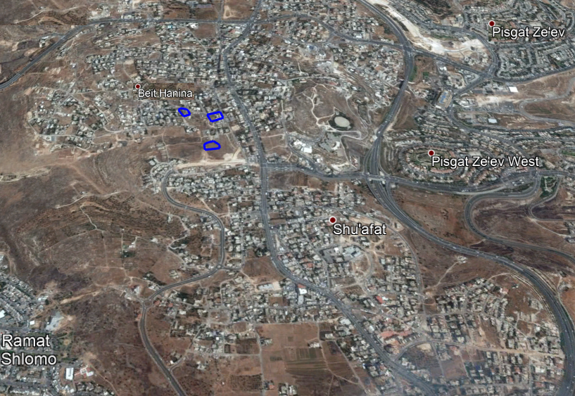
blog